Version History
Here you can find the changelog of Hiking Trail HK since it was posted on our website on 2016-11-07.
The latest version is and it was updated on soft112.com on 27 April, 2024.
See below the changes in each version:
version N/A
posted on 2024-04-18
Update offline map.
version N/A
posted on 2024-02-02
- Improve text display color.
- Show the scrollbar of the button bar for round screens, to indicate that the bar is scrollable.
- Fix some issues.
version N/A
posted on 2023-09-01
Fix some issues.
version N/A
posted on 2023-05-26
Support route transfer between a watch and a phone via the Bluetooth connection between companion devices.
version N/A
posted on 2023-04-17
- Support track logging, route alert, and map search functions.
- Fix some issues.
version N/A
posted on 2023-03-27
- Support connecting to the Wear OS version.
- In order to update a library, need at least Android 4.4 to install the app now.
version 10.12
posted on 2022-04-28
- Support showing alternative names, and searching by those names.
- Fix some issues.
version 10.11
posted on 2022-04-05
- Support filtering trails using waypoint names in the Trail Search UI.
- Fix some issues.
version 10.10
posted on 2022-03-15
- Support searching certain types of objects, even though they are not in view.
- Fix some issues.
version 10.9
posted on 2022-01-28
- Support HK 1980 Grid Coordinates.
- Handle wrong device time better during positioning.
- Allow user to import GPX with data of wrong time format.
- Handle approximate location in Android 12 better.
- Fix some issues.
version 10.8.1
posted on 2021-12-22
- Fix an issue that sometimes a path segment may be selected even if the map is not long-pressed with two fingers.
- Fix some issues.
version 10.8
posted on 2021-11-13
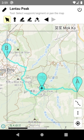
- Support selecting any path segments by long pressing the map with two fingers. Usage: https://hikingtrailhk.appspot.com/help.en.html#add_map_seg
- Fix some issues.
version 10.7
posted on 2021-09-11
- Support searching map objects by name.
- Support opening GPX and TBAK files with uppercase extensions.
version 10.6
posted on 2021-06-25
- Support showing bus route, website and wiki info for some map objects, and support highlighting those objects.
- Highlight sub-types, like Noodle Restaurant, Sushi Restaurant and etc, when highlighting Restaurant in map. Similar for Place of Worship.
version 10.5
posted on 2021-05-12
- Support showing cape, office, and etc in map.
- Support showing some building types.
- Update Google Play Billing Library.
- Fix some issues.
version 10.4
posted on 2021-03-30
- Support highlighting certain objects by their types.
- Fix an issue on Android 11 that map zoom/rotation does not work within the drawing area when the "Select waypoint/segment or pan the map" editor tool is used.
- Fix some other issues.
version 10.3
posted on 2021-01-29
- Show the map direction value when the map is rotated.
- Support dark theme.
- Fix some issues.
version 10.2.1
posted on 2020-11-19
- Fix an issue that some distance post numbers do not appear in the map, after the previous update.
- Fix some other issues.
version 10.2
posted on 2020-10-28
- Can check all displaying map objects in a location by tapping a coordinate link in the app.
- Support entering coordinate.
- Fix some issues.
version 10.1
posted on 2020-09-12
- Change the wordings of some map object types, and add some object types.
- Fix some issues.
version 10.0
posted on 2020-07-24
- Support showing map object information. (By tapping on icon or text, or long pressing, then moving the handle.)
- Fix some garbled characters.
- Fix some other issues.
version 9.5
posted on 2020-05-12
- Show hillshade. (May not work on some old devices.)
- Improve the display of contour lines.
- Show toilets in higher priority.
- Show more objects, like bus stops mapped as ways, names of ferry routes, and etc.
- Adjust the map fling velocity.
- Improve the map performance while using GPS related functions.
- Fixed an issue that the compass direction is not reliable when the device is in vertical position.
- Show more information in the purchase panel to fulfill the latest Google Play policy.
version 9.4
posted on 2020-02-27
- Show the names of some islets.
- Updated links to Enjoy Hiking.
- Fixed a very bold text issue when the high-contrast text system option is enabled.
- Tune the performance on some old devices.
version 9.3
posted on 2019-12-16
- Improve the map style:
* Show contour lines, and some other objects with more details in low zoom levels.
* Show vegetation regions with clearer colors.
* More colorful names.
* Icon size will increase when zoom in.
- Fix a track logger issue related to waypoint modification.
- Fix some crash issues in some old devices, after migrated to the new map engine.
- Fix some other issues.
- Add attributions to some 3rd party libraries.
version 9.2
posted on 2019-11-29
- Improve the map style:
* Improve path style again to prevent mixing up with selected trails or logged track.
* More colorful roads/POIs/lands.
* Clearer building outline.
* A bit clearer minor contour lines.
* Show some names earlier in lower zoom level.
* Show names for rocky lands.
- Fix some issues caused by last map library update - the scale bar shows incorrect scale, incorrect radar icon size.
version 9.1
posted on 2019-11-22
- Improve the map style.
- Show attached rock, boulder, and etc.
- Fix the unit used in the scale bar in English environment.
- Fix an issue that the map may not show direction correctly.
- Fix an issue that the map still show a direction arrow even if there is no compass in a device.
- Show the direction arrow in gray color if the direction data is unreliable.
- Fix an issue that the map will leave tracking modes after reset the rotation angle.
- Improve the rotation effect.
...
version 9.0
posted on 2019-11-14
- Change the map rendering engine to Mapbox - support rotation (see https://docs.mapbox.com/ios/maps/overview/interacting-with-the-map/ for gestures supported), but not support using larger font size.
- Prevent initializing the Mobile Ads SDK for paid users.
version 9.0
posted on 2019-11-14
- Change the map rendering engine to Mapbox.
- New engine supports rotation. Tapping the GPS button again will make the map rotate with the device. Tapping one more time can reset the map direction.
- Removed two zoom buttons. New engine supports four zoom related gestures (see https://docs.mapbox.com/ios/maps/overview/interacting-with-the-map/ for gestures supported).
- New engine does not support using larger font size.
- Prevent initializing the Mobile Ads SDK for paid users.
version 8.24
posted on 2019-09-12
- Fixed some issues on Android 10, like map display and route alert issues.
- On Android 10, there will be error when using Total Commander to import trails, please use the built-in "Files" app instead.
version 8.11
posted on 2018-02-21
Update the map.
version 8.2
posted on 2016-11-03
- Fixed an issue that Traditional Chinese UI language cannot be displayed on Android 7.0.,- Added Kau Keng Shan, Kowloon Peak, Pui-Ling Mountains Traverse, and etc.